![](/images/other/stat-length.png)
![Tour Wandern La Thuile - Savoyarde - Photo](https://media.geolcdn.com/t/1900/400/ext.pjpeg?maxdim=2&url=https%3A%2F%2Fstatic1.geolcdn.com%2Fsiteimages%2Fupload%2Ffiles%2F1553511878bg_sport_marche.png)
Savoyarde
patpounet73
Benutzer
![Länge](/images/other/stat-length.png)
Länge
11,6 km
![Maximale Höhe](https://static1.geolcdn.com/siteimages/upload/files/1508320355ic_sort_altitude_max_24dp.png)
Maximale Höhe
1197 m
![Positive Höhendifferenz](https://static1.geolcdn.com/siteimages/upload/files/1508320355ic_sort_den_pos_24dp.png)
Positive Höhendifferenz
488 m
![Km-Effort](/images/other/stat-length.png)
Km-Effort
18,1 km
![Min. Höhe](https://static1.geolcdn.com/siteimages/upload/files/1508320355ic_sort_altitude_min_24dp.png)
Min. Höhe
877 m
![Negative Höhendifferenz](https://static1.geolcdn.com/siteimages/upload/files/1508320355ic_sort_den_neg_24dp.png)
Negative Höhendifferenz
476 m
![Boucle](https://static1.geolcdn.com/siteimages/upload/files/16400158638029165_repeat_loop_refresh_sync_direction_icon.png)
Boucle
Ja
Erstellungsdatum :
2015-11-12 00:00:00.0
Letzte Änderung :
2015-11-12 00:00:00.0
![Wandern](https://static1.geolcdn.com/sitytour/trail-icons/101.png)
4h02
Schwierigkeit : Medium
![Scannen Sie diesen QR-Code, um die Tour in der SityTrail-Anwendung zu öffnen](https://capi.geolives.com/qq0zvz2zws4bq2lad0pu/sitytour/trails/411096/qr.png?size=200)
Kostenlosegpshiking-Anwendung
Über SityTrail
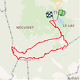
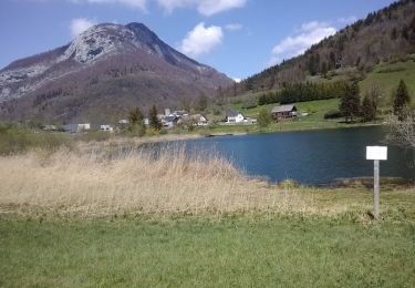
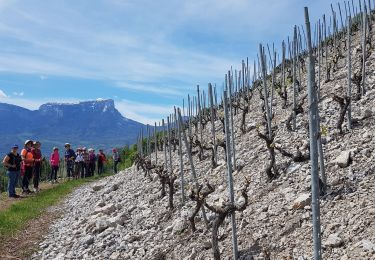
Tour Wandern von 11,6 km verfügbar auf Auvergne-Rhone-Alpen, Savoyen, La Thuile. Diese Tour wird von patpounet73 vorgeschlagen.
Beschreibung
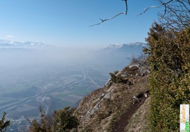
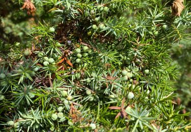
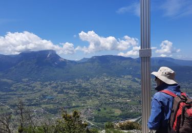
Boucle avec partie aériennes et superbes panoramas du rocher de Tormery (passage avec échelles dans la falaise)au rocher de Manettaz. A faire par temps sec.
Ort
Land:
France
Region :
Auvergne-Rhone-Alpen
Abteilung/Provinz :
Savoyen
Kommune :
La Thuile
Standort:
Unknown
Gehen Sie:(Dec)
Gehen Sie:(UTM)
270062 ; 5046089 (32T) N.
Kommentare
Touren in der Umgebung
![Tour Wandern Arbin - La Roche du Guet depuis Arbin, Montmélian - Photo](https://media.geolcdn.com/t/375/260/ext.jpg?maxdim=2&url=https%3A%2F%2Fservices.sitytrail.com%2FGeolivesWS%2FDownloadMedia.ashx%3FTrailID%3D106315%26Media%3D10750_1.jpg)
![Wandern Wandern](https://static1.geolcdn.com/sitytour/trail-icons/101.png)
La Roche du Guet depuis Arbin, Montmélian
Wandern
Medium
(1)
Arbin,
Auvergne-Rhone-Alpen,
Savoyen,
France
![](/images/other/stat-length.png)
9,5 km | 21 km-effort
6h 0min
![](https://static1.geolcdn.com/siteimages/upload/files/16400158638029165_repeat_loop_refresh_sync_direction_icon.png)
Ja
![Tour Wandern Aillon-le-Jeune - La Pointe de la Galoppaz 1680m, depuis le Col du Lindar - Photo](https://media.geolcdn.com/t/375/260/ext.jpg?maxdim=2&url=https%3A%2F%2Fservices.sitytrail.com%2FGeolivesWS%2FDownloadMedia.ashx%3FTrailID%3D103728%26Media%3D6391_1.jpg)
![Wandern Wandern](https://static1.geolcdn.com/sitytour/trail-icons/101.png)
La Pointe de la Galoppaz 1680m, depuis le Col du Lindar
Wandern
Einfach
(1)
Aillon-le-Jeune,
Auvergne-Rhone-Alpen,
Savoyen,
France
![](/images/other/stat-length.png)
7,4 km | 14,9 km-effort
3h 45min
![](https://static1.geolcdn.com/siteimages/upload/files/16400158638029165_repeat_loop_refresh_sync_direction_icon.png)
Nein
![Tour Mountainbike La Thuile - Bauges - La vallée du Lindar - Photo](https://media.geolcdn.com/t/375/260/ext.jpg?maxdim=2&url=https%3A%2F%2Fservices.sitytrail.com%2FGeolivesWS%2FDownloadMedia.ashx%3FTrailID%3D102183%26Media%3D2575_1.jpg)
![Mountainbike Mountainbike](https://static1.geolcdn.com/sitytour/trail-icons/202.png)
Bauges - La vallée du Lindar
Mountainbike
Schwierig
(1)
La Thuile,
Auvergne-Rhone-Alpen,
Savoyen,
France
![](/images/other/stat-length.png)
18 km | 31 km-effort
3h 0min
![](https://static1.geolcdn.com/siteimages/upload/files/16400158638029165_repeat_loop_refresh_sync_direction_icon.png)
Ja
![Tour Wandern La Thuile - roche de Guet et Roc d Tormery - Photo](https://media.geolcdn.com/t/375/260/e3e63a57-8149-490c-b05a-84cb7ccee5b7.jpg&format=jpg&maxdim=2)
![Wandern Wandern](https://static1.geolcdn.com/sitytour/trail-icons/101.png)
roche de Guet et Roc d Tormery
Wandern
Einfach
La Thuile,
Auvergne-Rhone-Alpen,
Savoyen,
France
![](/images/other/stat-length.png)
10,1 km | 17,6 km-effort
2h 48min
![](https://static1.geolcdn.com/siteimages/upload/files/16400158638029165_repeat_loop_refresh_sync_direction_icon.png)
Ja
![Tour Wandern La Thuile - Balade au lac de là Thuile - Photo](https://media.geolcdn.com/t/375/260/2c9dd213-d252-46e3-bfea-8a8c0abc45db.jpg&format=jpg&maxdim=2)
![Wandern Wandern](https://static1.geolcdn.com/sitytour/trail-icons/101.png)
Balade au lac de là Thuile
Wandern
Einfach
La Thuile,
Auvergne-Rhone-Alpen,
Savoyen,
France
![](/images/other/stat-length.png)
9,7 km | 13,9 km-effort
3h 39min
![](https://static1.geolcdn.com/siteimages/upload/files/16400158638029165_repeat_loop_refresh_sync_direction_icon.png)
Ja
![Tour Wandern Curienne - Boucle de curienne - Photo](https://media.geolcdn.com/t/375/260/bf0e46c4-b1d7-4727-95a4-0b49e6273a30.jpg&format=jpg&maxdim=2)
![Wandern Wandern](https://static1.geolcdn.com/sitytour/trail-icons/101.png)
Boucle de curienne
Wandern
Einfach
Curienne,
Auvergne-Rhone-Alpen,
Savoyen,
France
![](/images/other/stat-length.png)
6,2 km | 9,1 km-effort
2h 22min
![](https://static1.geolcdn.com/siteimages/upload/files/16400158638029165_repeat_loop_refresh_sync_direction_icon.png)
Ja
![Tour Nordic Walking Chignin - Chignin - Arbin à travers les vignes et coteaux - Photo](https://media.geolcdn.com/t/375/260/57c2a674-7c91-4476-9328-bd442983023e.jpg&format=jpg&maxdim=2)
![Nordic Walking Nordic Walking](https://static1.geolcdn.com/sitytour/trail-icons/102.png)
Chignin - Arbin à travers les vignes et coteaux
Nordic Walking
Medium
Chignin,
Auvergne-Rhone-Alpen,
Savoyen,
France
![](/images/other/stat-length.png)
15,2 km | 21 km-effort
3h 36min
![](https://static1.geolcdn.com/siteimages/upload/files/16400158638029165_repeat_loop_refresh_sync_direction_icon.png)
Ja
![Tour Wandern La Thuile - Crêtes de la Savoyarde - Photo](https://media.geolcdn.com/t/375/260/d3370867-f364-46cd-b9bc-1d45c5787cc5.jpg&format=jpg&maxdim=2)
![Wandern Wandern](https://static1.geolcdn.com/sitytour/trail-icons/101.png)
Crêtes de la Savoyarde
Wandern
Schwierig
La Thuile,
Auvergne-Rhone-Alpen,
Savoyen,
France
![](/images/other/stat-length.png)
10,9 km | 19,9 km-effort
6h 21min
![](https://static1.geolcdn.com/siteimages/upload/files/16400158638029165_repeat_loop_refresh_sync_direction_icon.png)
Nein
![Tour Mountainbike Arbin - les vignes et la combe de Savoie - Photo](https://media.geolcdn.com/t/375/260/ext.jpg?maxdim=2&url=https%3A%2F%2Fservices.sitytrail.com%2FGeolivesWS%2FDownloadMedia.ashx%3FTrailID%3D409827%26Media%3Dfix__20150419131616.jpg)
![Mountainbike Mountainbike](https://static1.geolcdn.com/sitytour/trail-icons/202.png)
les vignes et la combe de Savoie
Mountainbike
Medium
(1)
Arbin,
Auvergne-Rhone-Alpen,
Savoyen,
France
![](/images/other/stat-length.png)
25 km | 33 km-effort
3h 24min
![](https://static1.geolcdn.com/siteimages/upload/files/16400158638029165_repeat_loop_refresh_sync_direction_icon.png)
Nein